outline_earth

This IDL facility generates an outline of the Earth continents, coast lines, countries and/or rivers, at various resolution, which can then be overplotted onto HEALPix maps using the outline option of cartview, gnomview, mollview or orthview.

Location in HEALPix directory tree: src/idl/visu/outline_earth.pro 


FORMAT

IDL> geo = OUTLINE_EARTH([geo_in], [BEHAVIOR=, /COASTS, COLOR=, /CONTINENTS, /COUNTRIES, /HELP, HIRES=, LINESTYLE=, /RIVERS, THICK=])


QUALIFIERS

geo
output IDL structure
geo_in
optional input IDL structure generated by a previous call to outline_earth, which will be included into the output geo (see Example)


KEYWORDS

BEHAVIOR=
either 'GDL', 'IDL' or absent: changes the origin of the Earth data (see below)

/COASTS
if set, adds coastlines, islands, and lakes information in geo with the features COLOR, LINESTYLE and THICK.

COLOR=
scalar or 2-element array: color index to be given to geographical data in final plot in [0, 255]. See outline of mollview for details.

/CONTINENTS
if set, adds continental boundaries

/COUNTRIES
if set, adds political boundaries (as of 1993)

/HELP
if set, prints extended help

HIRES=
if set >0 use high resolution information (if it is available) instead of default low resolution one.
Either 0 or 1 (and more) in IDL mode;
in 0,1,2,3,4 in GDL mode.
Beware that Hires data are voluminous, longer to process and will result in large PNG or PDF files when plotted with eg mollview

LINESTYLE=
linestyle given to current geographical outline(s). default:0. See outline of mollview for details.

/RIVERS
if set, adds rivers

THICK=
thickness of the geographical lines default:1.0. See outline of mollview for details.


DESCRIPTION

outline_earth reads Earth data from disk (see below) and generates outlines of the Earth continents, coast lines, countries and/or rivers (in combination or separately), at various resolution, with a user-specified color, linestyle and thickness, which can then be overplotted onto HEALPix maps using cartview, gnomview, mollview or orthview.
– If run under IDL (or if BEHAVIOR='IDL') the Earth data are read from $IDL_DIR/resource/maps/*/*.* with 'low' (HIRES=0) and if available 'high' (HIRES$\ge$1) resolution.
– If run under GDL (or if BEHAVIOR='GDL') the GSHHS data (version 2.2 or more, available at https://www.ngdc.noaa.gov/mgg/shorelines/data/gshhg/latest/gshhg-bin-*.zip) are read from $GSHHS_DATA_DIR/*.b with HIRES=0,1,2,3,4 standing for 'coarse', 'low', 'intermediate', 'high' and 'full' resolution respectively.
In GDL mode, Coasts and Continents are degenerate.
– Under FL, BEHAVIOR must be set to either 'IDL' or 'GDL', and the corresponding data must be available .


RELATED ROUTINES

This section lists the routines related to outline_earth

idl
version 6.4 or more is necessary to run outline_earth.
cartview, gnomview
mollview, orthview
visualization routines that overplot the Earth geographical outlines generated by outline_earth)


EXAMPLE:

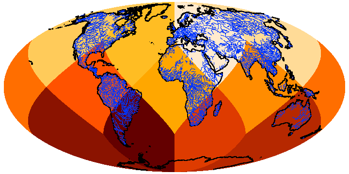
geo = outline_earth(/continents,/hires,thick=0.8)
geo = outline_earth(geo, /rivers, thick=0.1,col=20)
mollview, findgen(12), $
outline=geo, /flip, coord=['C','C'], $
min=-11,max=11,colt='planck1',/crop
Creates a structure containing a thick-lined high-resolution continent outline, adds a thin-lined lower resolution rivers outline, in a different color, and then overplots the combination on a Mollweide projection of a (simple) HEALPix map (see Fig. 6) Note that since Earth data (generated in Celestial = eQuatorial coordinates) are usually shown with the longitude increasing from left to right (contrary to astronomical data), the flip keyword must be set in mollview.

Figure 6: Illustration of the Earth outlines created by outline_earth.
Image outline_earth

Version 3.82, 2022-07-28